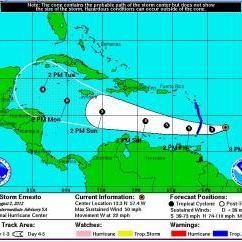
Tropical Storm Ernesto is currently tracking towards portions of the Caribbean Islands. The Air Force Reserve Hurricane Hunters have measured sustained wind speeds of 50mph with higher gusts. The storm is expected to continue to strengthen over the next 48 hours.
This graphic shows an approximate representation of coastal areas under a hurricane warning (red), hurricane watch (pink), tropical storm warning (blue) and tropical storm watch (yellow). The orange circle indicates the current position of the center of the tropical cyclone. The black line, when selected, and dots show the National Hurricane Center (NHC) forecast track of the center at the times indicated. The dot indicating the forecast center location will be black if the cyclone is forecast to be tropical and will be white with a black outline if the cyclone is forecast to be extratropical. If only an L is displayed, then the system is forecast to be a remnant low. The letter inside the dot indicates the NHC's forecast intensity for that time:
D: Tropical Depression – wind speed less than 39 MPH
S: Tropical Storm – wind speed between 39 MPH and 73 MPH
H: Hurricane – wind speed between 74 MPH and 110 MPH
M: Major Hurricane – wind speed greater than 110 MPH
- Login to post comments


Recent comments
9 years 50 weeks ago
10 years 18 weeks ago
10 years 22 weeks ago
10 years 25 weeks ago
10 years 26 weeks ago
12 years 45 weeks ago
13 years 7 weeks ago
13 years 27 weeks ago